
Why this matters
Most retirement advice still focuses on state-level rankings, generalized cost-of-living lists, or broad “best places to retire” concepts. Those are useful starting points, but they often miss the local conditions that shape actual retirement life.
A retiree does not experience a statewide average. They experience a specific place, a specific ZIP code, a specific healthcare network, a specific housing market, and a specific set of day-to-day tradeoffs.
That matters because a retirement location can look affordable on paper while quietly creating healthcare, climate, transportation, tax, or livability tradeoffs that only become obvious after someone has already moved.
The data problem: retirement information is fragmented
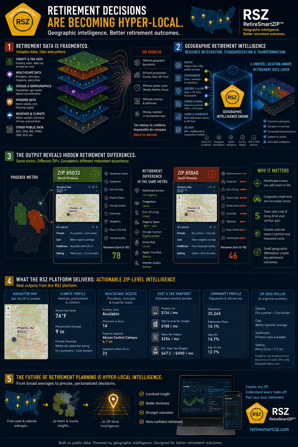
The data needed for retirement location planning is spread across different agencies, formats, geographies, and update schedules. Some data is state-level. Some is county-level. Some is ZIP-level. Some comes from weather stations, healthcare provider files, housing datasets, or geographic reference layers.
That means the hard part is not simply finding one dataset. The hard part is integrating many inconsistent datasets into one usable, location-aware retirement view.
Fragmented sources
County taxes, ZIP housing, healthcare access, climate stations, demographics, and metro geography.
Geographic normalization
Standardization, ZIP mapping, proximity calculations, data enrichment, and decision-support modeling.
Localized intelligence
Clearer comparisons showing why nearby ZIPs can produce different retirement realities.
Why broad retirement rankings often fail retirees
State and city rankings can be useful for early discovery, but they often blur the differences that shape real retirement outcomes. A state may appear affordable while a specific metro is expensive. A city may look attractive while nearby ZIP codes differ sharply in home values, hospital access, congestion, climate comfort, and tax exposure.
This is why ZIP-level retirement analysis changes the conversation. People are not only asking where the best state to retire might be. They are trying to compare retirement affordability by ZIP code, healthcare access by ZIP, housing pressure, climate comfort, and day-to-day livability in the specific places they may actually live. RetireSmartZIP is designed to help people think in ZIP codes, not just cities.
RetireSmartZIP is designed to help turn broad location research into a clearer shortlist of places that deserve deeper investigation — not to replace personal financial, medical, tax, or legal advice.
What retirees increasingly want to compare
Retirement location decisions are becoming more practical and local. Many people are no longer satisfied with broad lists of “best places to retire.” They want to understand how a place may actually work for their budget, health needs, climate preferences, and lifestyle.
- Retirement cost of living by ZIP code, not just by state
- Housing affordability compared with nearby communities and regional averages
- Healthcare access, hospital proximity, and practical care availability
- Climate comfort, heat exposure, seasonality, and local environmental context
- Monthly tax burden signals, including property, income, and sales-tax assumptions
- Community feel, metro relationship, and whether a place feels urban, suburban, or small-town
Two retirees with similar savings can experience very different outcomes depending on these local tradeoffs. One ZIP may reduce monthly pressure and improve access. Another may create hidden strain even inside the same city or metro area.
What RetireSmartZIP is trying to surface
RetireSmartZIP is built around the idea that retirement decisions are not just financial. They are geographic, practical, and local.
- Housing affordability and regional comparison
- Estimated monthly tax burden
- Healthcare access and hospital proximity
- Climate profile and seasonal comfort
- Community and retiree-mix signals
- Metro relationship and geographic context
The goal is not to make the decision for someone. The goal is to make local tradeoffs visible enough that people can decide which ZIPs deserve a deeper look — and which places may need more caution before becoming part of a retirement plan.
Why ZIP-level analysis changes the conversation
Two ZIP codes inside the same metro can produce different retirement realities: different hospital access, different congestion, different home values, different tax pressure, different climate profiles, and different day-to-day livability.
That is why RetireSmartZIP focuses on ZIP-level retirement intelligence rather than broad averages alone. State and city averages can start the search, but ZIP-level context helps test whether a location actually works.
Keep exploring the RetireSmartZIP framework
This article explains the platform thesis. The next step is to test specific places, review the methodology, and compare real examples where cost, housing, healthcare, and local context change the retirement picture.